South Africa spoiled hiking for me. There’s no better paradise for hikers than at the tip of Africa, specifically in the Western Cape. Where else in the world can you get jagged peaks, lush valleys, hidden waterfalls, refreshing swimming holes, and epic views for days?
Read on for ten of my favourite hikes in the Western Cape. You can find all within a few hours drive of the Mother City. They are listed in no particular order of preference – visit them all.
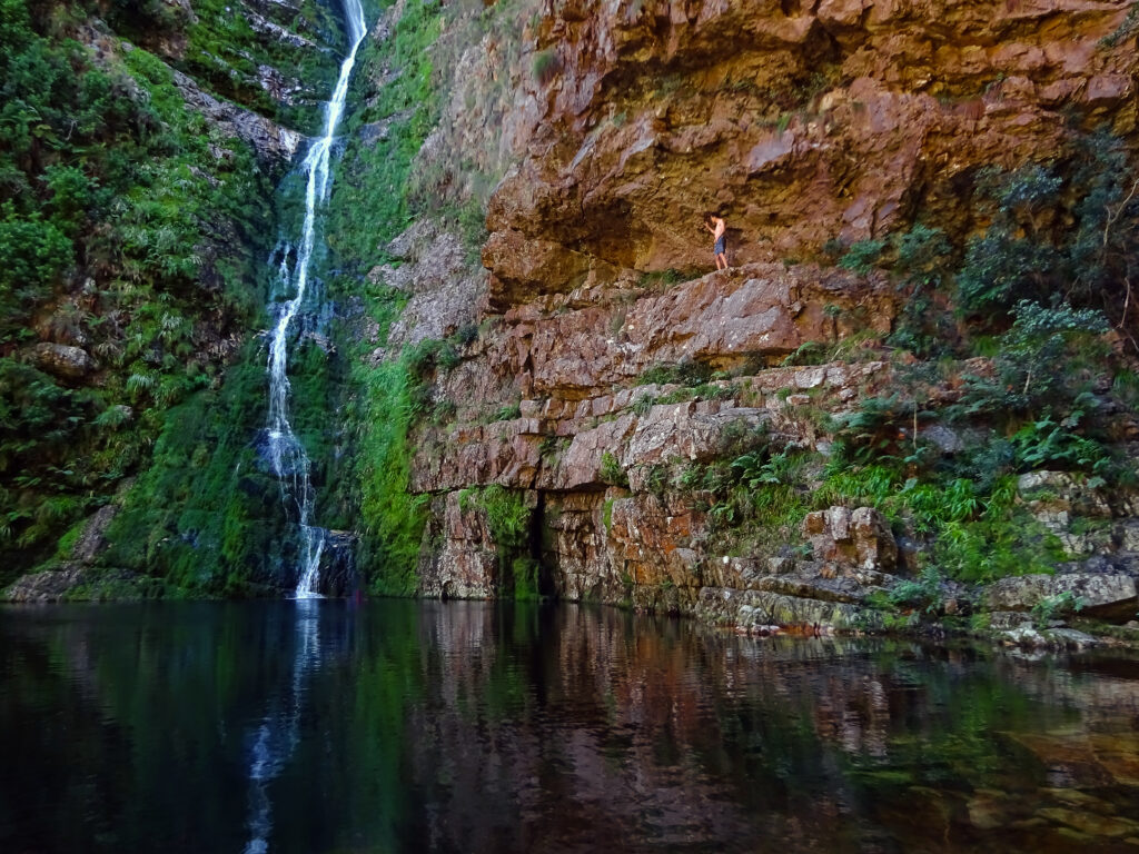
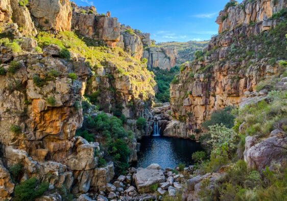
Krom River, Limietberg Nature Reserve
Day Hike, 8km, 1 hr drive from Cape Town
Hiding just after the N1 tunnel towards Worcester is the trail start to probably one of the most rewarding day hikes in the Western Cape. Krom River trail, as the name describes, follows the Krom River upstream along a semi-shaded trail, passing multiple small swimming holes along the way before it ascends upward into a valley. From here, you walk along a stoney cliff face until you reach a large pool and waterfall with a series of chains to your left. Follow these chains upwards and continue along the river until you get to the end of the hike – a super tall narrow waterfall feeding into a pool of icy cold water, perfect to dip in after sweating your way here.
The best time to visit is in the morning when the sun hits the pool. Go on a hot day to enjoy a swim. You can get permits for this hike via Cape Nature. Unfortunately, many people do not get permits. The high levels of foot traffic have ecologically damaged the area. So please, make sure you aren’t one of these people, and respect the permit-entry system.
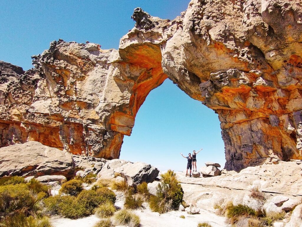
Wolfberg Arch, Cederberg
Day Hike, 12km, 3 hr drive from Cape Town
Further afield, in a much drier part of the Western Cape is the Cederberg region – a region famous for its sandstone rock formations and well-preserved examples of San rock art. Perhaps one of the most popular (but not overcrowded) hikes in the area is up to the Wolfberg Arch through the Wolfberg Cracks. If you’re a fan of corn mazes or escape rooms, you’ll absolutely love finding your way for a good while between the two narrow canyon walls that make up Wolfberg Cracks. From there, you continue onwards on the plateau towards Wolfberg Arch. You can find the full hike description here.
You can find the start of this hike near the Sanddrif campsite, just beyond the Valley of the Red Gods. Permits are available at Dwarsrivier Farm (the reception for Sanddrif) along the dirt road about 2km before the campsite. The permit for Wolfberg Cracks is R50, and another R50 to hike to Wolfberg Arch (the land they lie in belongs to different owners). An amazing wine tasting experience is also available here at Cederberg Wines. Might as well make a weekend out of it.
Palmiet River, Kogelberg Nature Reserve
Day Hike, 8km, 2 hr drive from Cape Town
Kogelberg is my favourite nature reserve in the whole wide world. If I could spend the rest of my life anywhere, that would be it. It’s not that it’s the most dramatic of mountains, nor the most epic of hikes, but it is the kind of place that simply puts you at ease. Granted, the absolute lack of mobile reception might help with that. But there is something magical about the reserve that I can’t put my finger on.
The Palmiet River trail is extremely straightforward. You follow the river on a relatively flat trail through the mountainous valley for 4km through fynbos until you come to a sandy beach. Then you put on your swimsuit and just enjoy being there, far from anyone or anything. If you want to spice things up a bit, I personally found floating down the river on the mini rapids in a tube highly entertaining. Eventually you walk back the same way you came.
You should pre-book permits for this hike with Cape Nature.
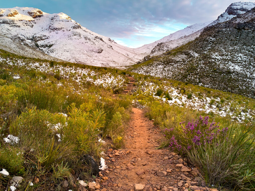
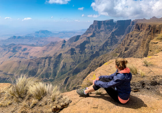
Perdekop, Mont Rochelle Nature Reserve
Day Hike, 13km, 1 hr drive from Cape Town
Franschhoek is well-known for its exquisite valley of vineyards surrounded by majestic mountain peaks. But did you know you can hike these? Mont Rochelle, a privately-owned nature reserve, boasts hikes of several lengths from thirty minutes up to seven hours for its longest – Perdekop.
This loop trail brings you on a relentless ascent (850m total) towards Perdekop before sweeping back down towards the hike start. At the Perdekop peak, you’ll be rewarded with endless views of the mountains and dams. You can even see Table Mountain on a clear day. Go in winter and you might even be treated to snow. On the way back, make sure you take the detour to Uitkyk – the view is beyond your imagination.
You can pre-book your permits here, or just buy them at the hut at the entrance to the reserve.
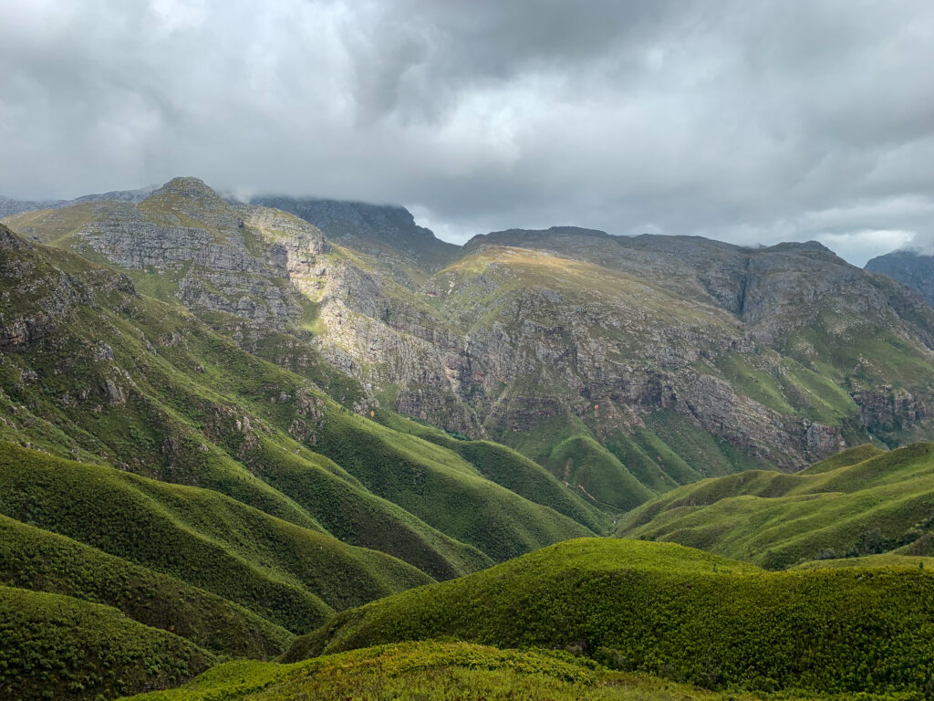
Panorama Route, Jonkerhoek Nature Reserve
Day Hike, 13km, 1 hr drive from Cape Town
This loop trail is long, but it lives up to its name. It is probably the most panoramic route I’ve ever been on in my life. You’ll climb about 900m in the first 6 km, up and around the valley. At around the halfway point, there are very dramatic views of another valley you can glimpse through the mountain pass. When you head back down, just be really careful – the steep trail crumbled quite a bit and it’s really easy to fall. On your way back, you’ll pass a few waterfalls you can detour to for a swim.
Just one word of caution – on hotter days, watch out for snakes. We had a puff adder slither a few inches behind us while we were taking a lunch break at one of the waterfalls.
You can get a permit at the gate, but make sure you come early! Parking within the reserve is very limited and fills up quickly. The walk from the reserve gate to the hike start is very long and I wouldn’t recommend it. (Also, it does help to have a car with good ground clearance – the road was in pretty bad condition the last time I went in 2021.)
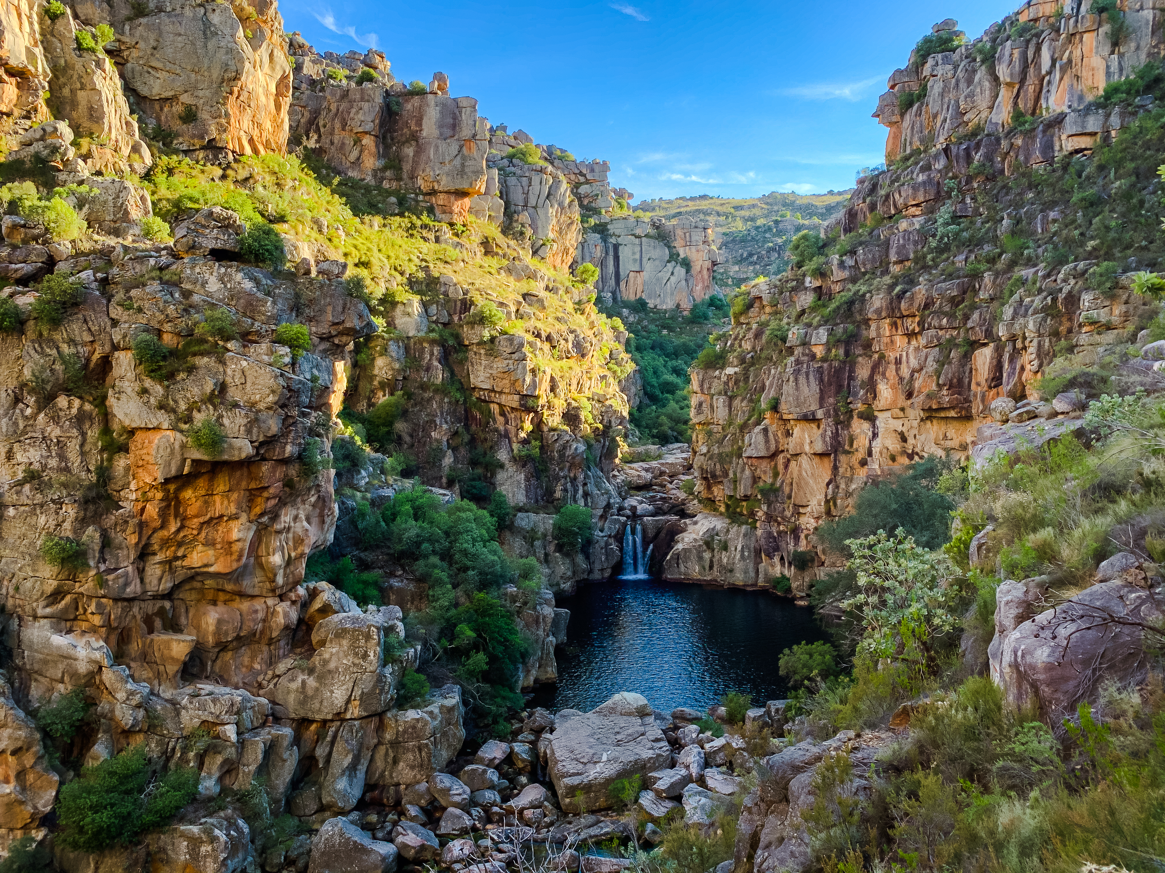
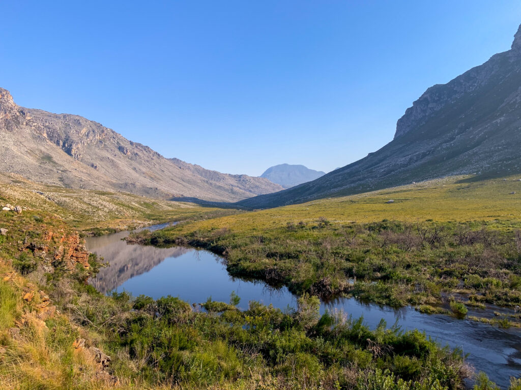
Die Hel, Groot Winterhoek Wildnerness Area
Overnight Hike, 12 – 20 km on Day 1, 18 km Day 2, 3 hr drive from Cape Town
Die Hel is a misleading name for a little slice of heaven tucked away deep in the South African wilderness. This two-day hike is well worth the effort of getting to this hidden gem of a rock pool. You can choose to do this as either an in-and-out trail following the same path along the river, there and back again. Or you can turn it into a loop trail by heading via Groot Kliphuis. Either way you can’t really go wrong.
You can either pre-book and stay at one of the overnight huts (bring your own sleeping bag) at De Tronk or camp anywhere you’d like. We camped at De Tronk and set off to Die Hel in the morning before we headed back. Though it was really cold at Die Hel at 6am in the morning, the lighting hit the pool perfectly. If you want to swim, it’s worth getting there by mid-morning. Otherwise, the sun will have moved on by the afternoon. If you missed your swimming opportunity, no worries – there are plenty of pools along the Kliphuis river.
WARNING! The trail is NOT marked. For the full hike details so you don’t get lost, read more here.
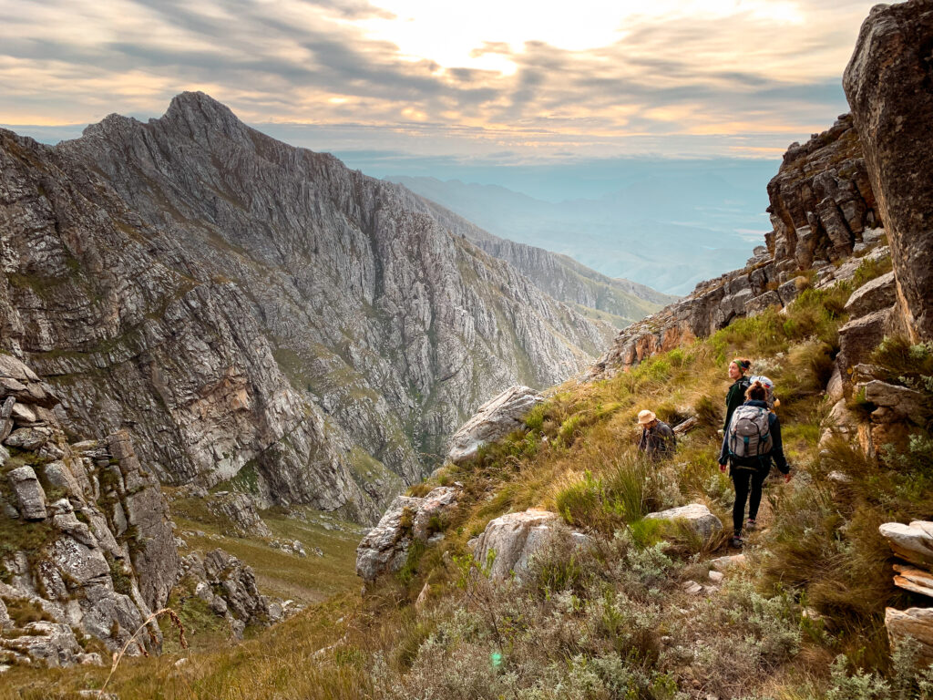
Arangieskop, Dassieshoek Nature Reserve
Overnight Hike, 9km + 1200m elevation gain on Day 1, 10km + 1370m elevation loss on Day 2, 3 hr drive from Cape Town
Arangieskop is known as Mount Kilimanjaro of the Western Cape, and not for no good reason. It’s steep. You will spend the first day going up, uP, UP. And the second day, going down, doWN, DOWN. It’s also probably one of my favourite hikes of all time.
There aren’t many times you’ll have an entire 1696m mountain to yourself. But this is one of them. When you book the permits for this hike, literally no one else can be on the mountain. You have full access to the mountain hut at the top, with braai facilities and even hot water (if you can figure out the donkey boiler).
If this sounds like your thing, read how to do the hike here.
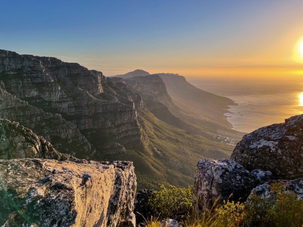
India Venster and Kasteelspoort, Table Mountain Nature Reserve
Day Hike, 9.6km
Table Mountain is beautiful looking up at it and hiking around on top of it. There are many different routes you can take to get to the top, but one of the most fun is India Venster, and the most scenic might be Kasteelspoort.
If exposure to heights isn’t your thing, then maybe skip this section and head to the next hike. India Venster is not for the faint-hearted. I was terrified my first time up this route.
The most popular route up Table Mountain, is undoubtedly the cable car. India Venster is the route you see crazy people hiking up as you pass over them from that cable car. It’s an incredibly steep ascent, but if you stick to the route (and maybe hike with someone who’s done it before), you’ll be totally fine. Just take some breaks to catch your breath.
You can find the route behind the cable car station. You follow this upwards until you get to a junction. Turn slight right, but so that you go upwards (not flat along the Pipe Track). You’ll ascend 750m before you reach the upper cable car station by looping around the backside of the mountain (passing a few abseilers perhaps). Depending on your fitness, you can complete this section in about 2 hours or less. AllTrails has a route you can follow if you need help. I wouldn’t attempt this ascent in heavy wind, rain, or cloudy conditions. People do die.
To head back down, you can take the cable car, or you can continue down into Echo Valley and then towards the Twelve Apostles to head down via Kasteelspoort into Camps Bay. That would take you at least 3 hours to complete. AllTrails has a useful map of this route here.
Skeleton Gorge via the dams, up Disa Gorge to Maclears Beacon and down Platteklip, Table Mountain Nature Reserve
Day Hike, 10km
From the southern suburbs side of Table Mountain, arguably the best route up is via Skeleton Gorge. This is the far more vegetated side of the mountain where you can hike through old forests. And it pops you out at the dams and near the route towards the highest point of Table Mountain – Maclears Beacon. This route isn’t a typical one per say, but a combo of some of the better highlights of the mountain. I put together a trail route you can follow on Komoot here.
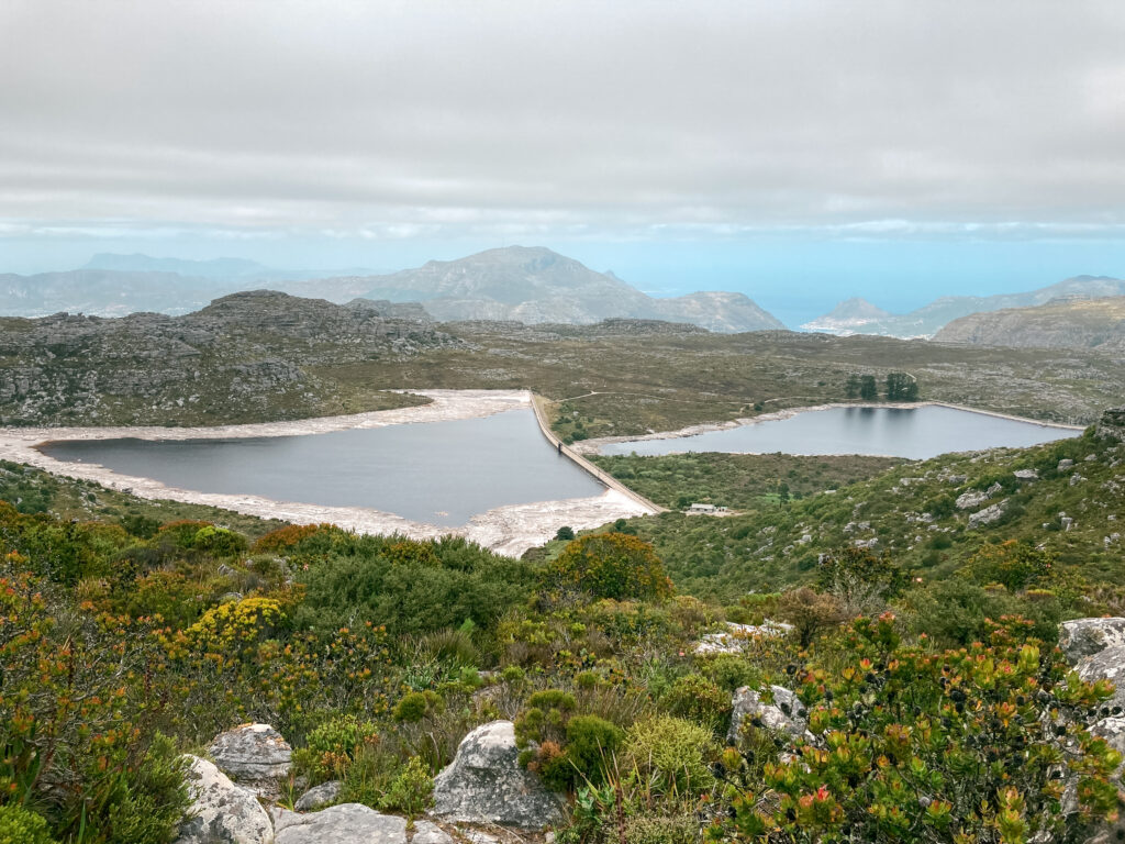
You’ll start up Skeleton Gorge from Kirstenbosch (you need a ticket to access this entrance, or you can start from Newlands Ravine for free). The way up is shaded – you’ll be scrambling up a gorge (after heavy rainfall, you might be scrambling up a waterfall). At the top you’ll approach the dams (technically, you shouldn’t swim in these – it’s the city’s drinking water). You’ll loop around one of the dams, cross a large stone dam wall and then continue your ascent along a stream. If you’re hiking here in January or February, you might catch some of the rare disas (a red flower that grows near water). There are rock pools here you could take a dip in if you wanted.
From there you follow a trail to your right along the old aqueduct before you make a left to go up the mountain along Smuts Track to Maclear’s Beacon – the highest point of Table Mountain. You’ll walk along this rather marshy plateau for a distance before you get to your descent: the overly popular Platteklip Gorge. It’s about 2km of stairs downwards, so if your knees hurt, take the cable car down. Otherwise, enjoy the view (and the company of many tourists).
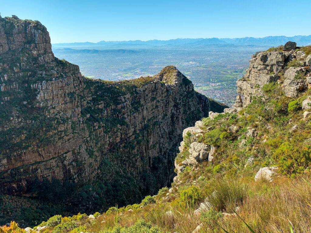
Devil’s Peak via Knife’s Edge, Table Mountain Nature Reserve
Day Hike, 9.6km
Devil’s Peak, the tall (1000m) hunky mountain peak next to the flat plateau of Table Mountain, tends to go ignored by visitors to the Mother City. Which is a shame, given it boasts one of the most challenging, but exciting trails you could hike within the city. It also has amazing views of Table Mountain That said, if you’re afraid of heights, this hike is not for you as you will be exposed to sheer drops along the way.
From Rhodes Memorial, behind the University of Cape Town campus, you’ll head up towards the Block House, before you take a sharp ascent of boulder-like stairs upwards. From here you follow the hump towards a trail with sheer drops at either side falling deep into a ravine below. Welcome to Knife’s Edge. Enjoy the adventure here, but don’t get too close to the edge.
After a bit of scrambling up to Minor Peak, you’ll get to a thick fynbos forest (unless this burnt away in a fire), that you’ll have to scratch your way through. You can either head down the mountain using a trail to your right, or continue straight to take the shortcut up to the summit of Devil’s Peak.
Be really careful to follow the cairns here marking the trail. It’s easy to miss. Ideally, check your phone as well to make sure you are falling the GPX track of the correct route. On one occasion, we missed the cairns above us and continued around the mountain peak before we found ourselves stuck on a very narrow ridge with a several hundred metre drop to our left. We had to jump a large crack in the ridge to move forward – if we had missed our step, we wouldn’t have made it. It was one of the most terrifying places to be and I wouldn’t repeat the experience.
From the summit, you’ve got two options to head back down. Either you can follow the trail to Tafelberg Road that will take you back towards the cable car station. Or you can hike around the mountain back to the Rhodes Memorial parking lot.
There’s a handy trail map you can follow on your phone here with AllTrails.
Not only is this a challenging hike with real exposure to drops, but it, unfortunately, has been the site of multiple attacks on hikers. That said, I cannot stress enough that you shouldn’t attempt this hike alone. Nor should you set out on a windy day. Otherwise, you might find yourself in a precarious position – like at the bottom of a ravine…