Nice to Know
Groot Winterhoek (Afrikaans for ‘Great Winter Corner’) is a wilderness area since 1985 and a UNESCO World Heritage site as part of the Cape Floral Region. As a wilderness area, hikers do not need to stick to trails, and camping is permitted just about anywhere (just don’t camp under the 300-6000 year old San rock art). Permits are available through Cape Nature. Conservation fees are waived for Wild Card holders. While four basic overnight huts are available (starting at R440), we opted to camp instead for R140 each.
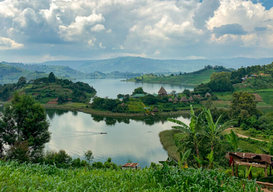
There are multiple paths and destinations of interest throughout the wilderness area. Only 2.5 hours from Cape Town, it’s fantastic as a weekend trip. Since we only had a 2-day weekend, we chose to visit the famous Die Hel (‘the hell’ in Afrikaans, or ‘steep dip’ in old Afrikaans).
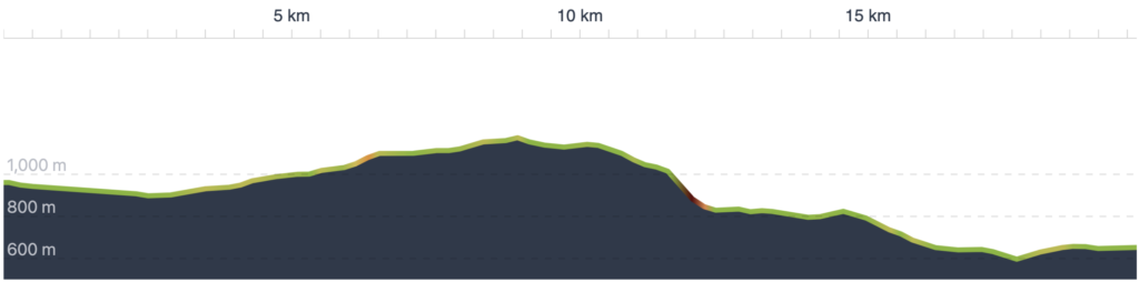
Day 1: Park Office to De Tronk via Groot Kliphuis 19.6km
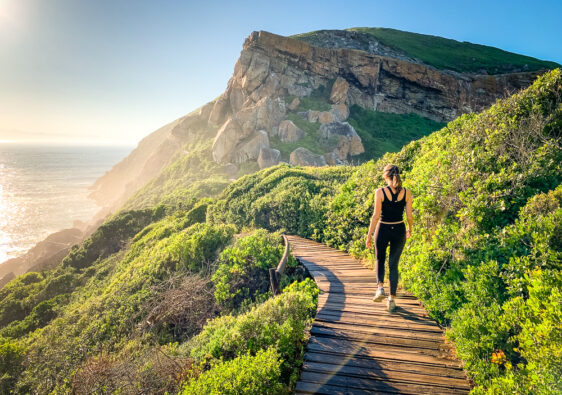
We set off later than what’s ideal, at about 11am since we drove in from Cape Town that morning. The sun was already sizzling hot, with temperatures of 33℃. If you plan to hike on a hot day, we’d recommend overnighting nearby in Porterville or at Beaverlac to avoid hiking in the full midday heat. The trail starts just down the jeep track from the parking lot and following a flat sandy path towards the mountains in the distance. About 1km is the first set of river crossings, follow the cairns to navigate a dry route. At 2.7km we passed Disa Pool, but with a long day ahead of us still, we didn’t stop to look.
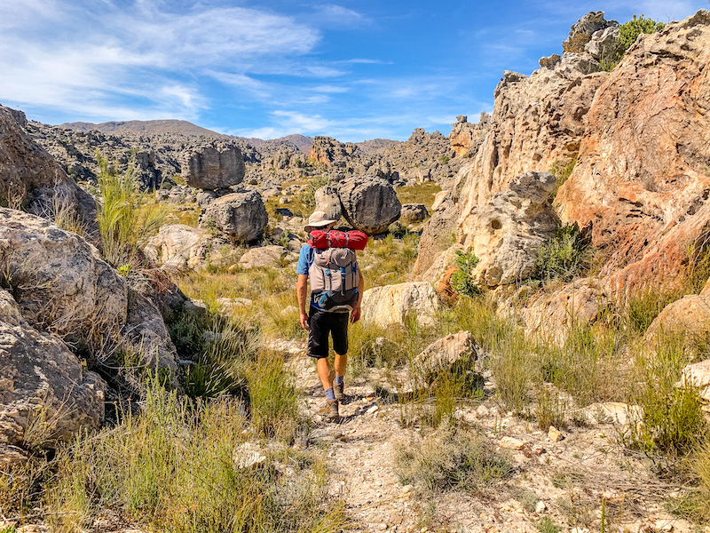
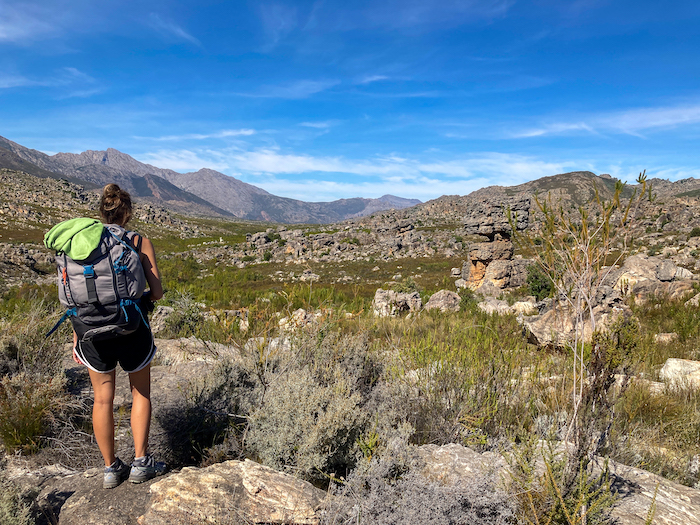
The next 7km sling away from the river, through rocky wide ravines before it opens out to a wide plain. You won’t have easy access to water during this section of the trail, so be sure to have a litre of water with you at least when you leave the Disa Pool. There are a few points you will need to climb up a rock face, so make sure you are looking for and following the cairns. We lost the trail at one point while clambering down a bunch of boulders, but were able to locate it again from our vantage point on top of a boulder.
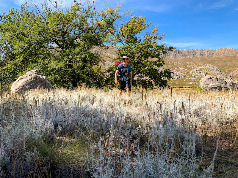
At 10km into the hike, you’ll descend down a hill through a very overgrown trail. About 700m to your left you will see a cluster of oak trees. These provided some of the only shade we had the whole hike, so we stopped here for a much needed lunch break. There’s a stream nearby where you can refill. You could choose to camp here if you want or you can continue like we did.
From the oak trees, it’s another 9-10km to where we set up camp at De Tronk. You follow the path straight back out of the oak trees, continue straight passing the trail you came from to your right, and descend into a green valley. There are a few steep, loose rock sections before you come to the bottom of the valley and find yourself in a small oasis of trees. From here, the trail gets very overgrown. If you have long pants, now is the time to put them on. The trail is relatively flat until you come to a small pool of water (refill again here), before it goes uphill and then downhill again to meet a jeep track. There are a few rocky sections, but keep following the cairns and you will find your way back to the trail.
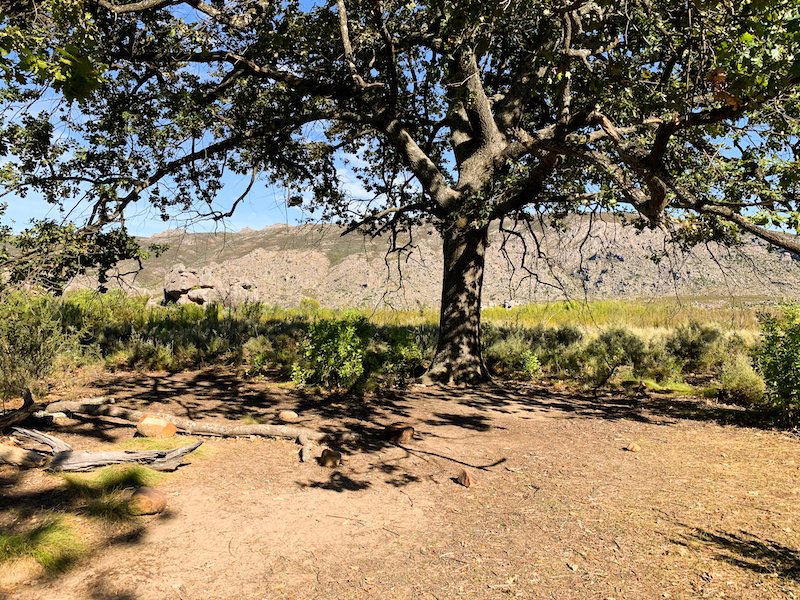
The last 3km are a bit of a bore since you follow the jeep track down towards a river and then up to the huts. If you are camping, keep walking past the huts until you pass all four. Just after the path up to Suikerbekkie you will see oak trees. Keep following the trail forward as if you are going to Die Hel and set up camp under the oak trees just before the bridge. There’s a stream right by those trees that you can get fresh water from and also take a much needed dip in.
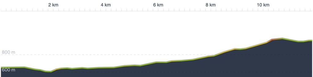
Summary stats: To cover 19.6km, with +400m/-710m elevation, we walked 5:13hrs, excluding about 45 minutes of breaks. (Word of caution - make sure you know what pace you can reasonably maintain over long distances with a heavy pack rather than plan your trip using our pace.)
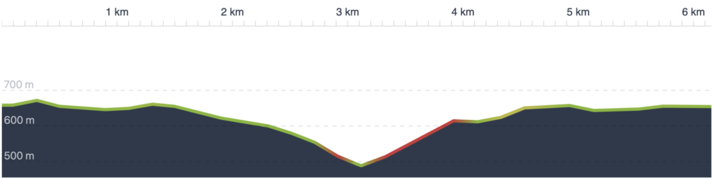
Day 2/Part 1: De Tronk to Die Hel and back 6.15km
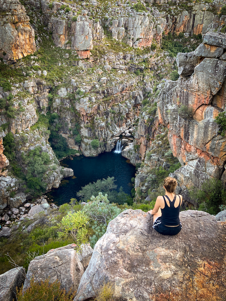
Since we planned to get back to Cape Town at the end of the day, we woke up at dawn to quickly hike down to Die Hel. We packed up our things but left our camping gear behind to lighten the load. The hike is relatively flat and follows an overgrown path with a lot of very painful plants before you descend quite steeply into a canyon. The path is very loose so be careful especially with heavy packs. There’s a ledge about 1/4 of the way down that you can take photos of Die Hel from.
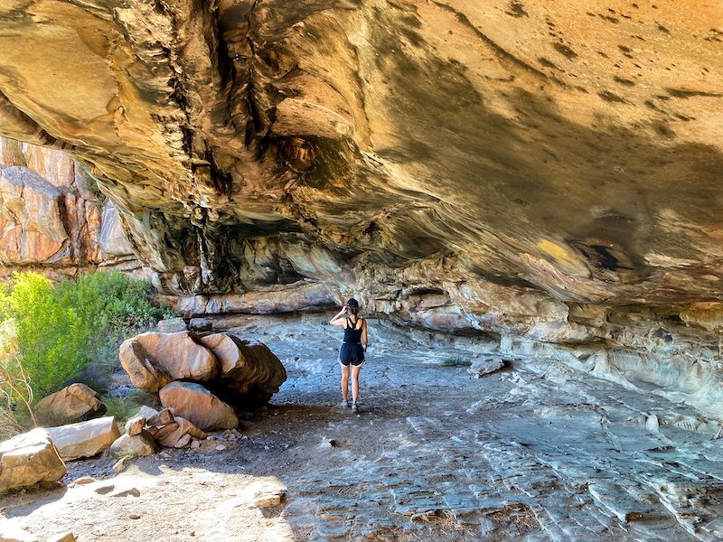
A few metres downwards from there is a small path to the left, barely noticeable that we missed it the first time. If you turn here, you will walk along a ledge up to a very long cave with San rock art. It looks like people have camped here and even made fires – please don’t follow in their footsteps – you’ll ruin the rock art.
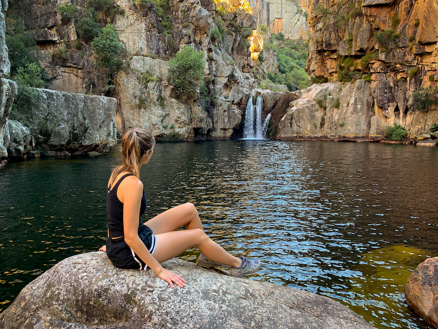
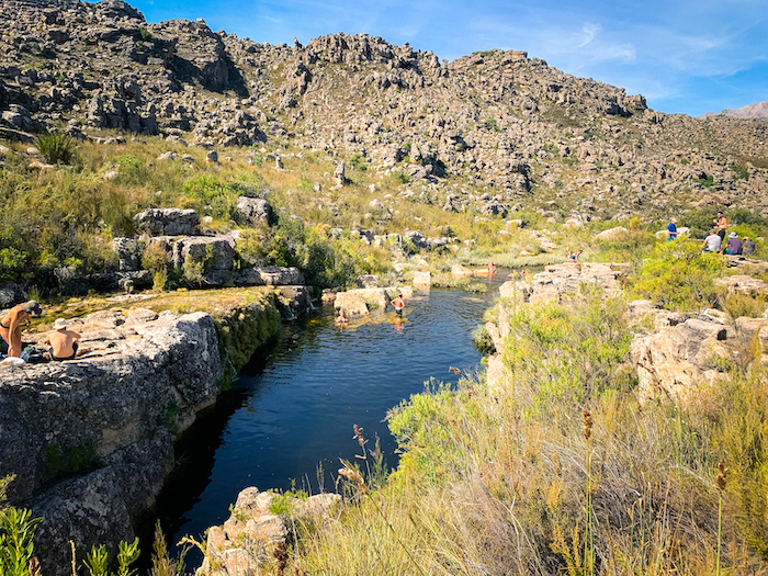
All the way at the bottom you can visit Die Hel, one of the largest (if not the largest) rock pool in South Africa. It looks like there’s a limited window where the sun hits the rock pool. When we went (11 April 2021), the sun began hitting the pool at around 9:30am. There are some flat large rocks around where you could camp at near the pool, but I’d bring a very warm sleeping bag if I were you. To get back, return the same way you came.
Die Hel summary stats: To cover 6.15km, with +210m/-220m elevation, we walked 1:38hrs, excluding about 45 minutes of breaks.
Day 2/Part 2: De Tronk onwards to the Park Office via Groot Kliphuis River 11.9km
We gathered our things and set off around 10:30am, covering the 3km along the jeep track in record speeds. You’ll cross back over the bridge you entered on and follow the curve left. Right after you cross a low-water bridge (you’ll probably need to take your shoes off), to your right is a trail going into the bush. Technically, the trail isn’t long, but it is a bit exhausting because sections of it are very overgrown, and if you were wearing shorts, by now your legs will be very cut and you will want to manoeuvre carefully to avoid the worst plants. There’s a pool of water early on, but it’s not very nice. Keep hiking. About 4.5km into the trail is a far nicer rock pool with diving opportunities. Take a break here and refill your water. You’re going to need it.
For some reason, the last 4.5km were brutal. There was no shade, the path gets very rocky, and the incline increases. At the fork in the trail there’s a sign that indicates the trail to the right is closed. I’m pretty sure this leads to Protea Pool. We followed the open trail which led high up a hill before it descended (I hate that) back down to meet with a jeep track. You’ll follow this for about 2km back to the car park.
Groot Kliphuis River summary stats: To cover 11.9km, with +420m/-110m elevation, we walked 2:54hrs, with an additional 30 minutes of breaks.
What I would do differently
Since we arrived too late the first day to get in a visit to Die Hel during daylight, we had to visit early the next morning. I would rather power through the direct route to the campsite via the Groot Kliphuis River to De Tronk, chuck my gear there, and continue to Die Hel with the aim of getting there for an early afternoon swim (~1pm) while the sun is out and hot. The next day, I would take the same route back via the river and spend a longer time at the rock pool. The first day of our hike was very scenic, but it is very long for a quick weekend hike.
What to Pack
We brought along about 10kg worth of pack each, including our water. To lighten our gear, we wore the same hiking clothes both days, and had pajamas and a long sweater for the evening. We took our standard camping gear, except swapped out the comfy foam inflating mats (*tear*) for lighter blow-up mats. Sleeping bags that go down to 5℃ would have been great. In terms of food, we had peanut butter sandwiches for lunch the first day, and bagels and cold cuts for dinner. We only brought enough for breakfast the next morning – some granola bars. Otherwise, we had some biltong, dried fruit, and NikNaks for snacks. It was just enough.
We had 2 litres of water at the start of the hike. If you plan to go to De Tronk via Groot Kliphuis, I would recommend carrying 2L since there aren’t many easy refill points. Even then in the heat, we were dehydrated. For the rest of the hikes, you only need 1L of water since you can refill at many points. We brought along a filter and water purifying tablets. While we used the filter, we only caught very few bits of sand. The tablets went unused. The water is so clean and pure (especially where it is flowing steadily), you don’t need to filter or purify the water.
Long, loose hiking pants will save your legs from millions of hard, scratchy plants that will otherwise slice at your skin mercilessly on long sections of the trail (particularly along the trail to Die Hel, and the Klein Kliphuis river). I spent many hours thinking about the merits of long pants while feeling the pain of my decision to only pack shorts.
Bring some plastic bags to take your trash away with you.
For more route information and GPX tracks you can download to your device, you can find our trip on the Komoot app or online here.